Sahara Sea; Adventures in Macro-Engineering
Radical environmental engineering ideas are not new, especially in the face of plans to “fix” or defer the ravages of climate change. You could argue that we’ve been unwittingly (or negligently, depending on the what and when) doing it for our entire civilized existence. However, I’m talking about the process of doing so with an intentional project in mind. For example:
- Stratospheric aerosols, reducing incoming solar radiation to offset greenhouse gas effects.
- Ocean fertilization, super-charging beneficial oceanic ecosystems to offset human activities.
- Sequestration, capture and trapped, primarily of carbon dioxide in stable stratum.
Personally, I think addressing the causes is far more desirable and efficient and avoids the risk of unknown side-effects or failures of these sorts of techniques, but for the sake of mental exercise I’m playing an Obscure History Card to take a look at one that you probably never heard of.
Back in 1874, flush from humanity’s triumph in engineering the Suez Canal in 1869, a man named François Élie Roudaire was getting ideas about what else humans could accomplish in this dazzling new age.
A military geographer by trade, Roudaire had spent time performing surveys in Algeria, then a French colony and had become familiar with the region’s terrain. One particular aspect of the Saharan region that captured Roudaire’s imagination was chotts.
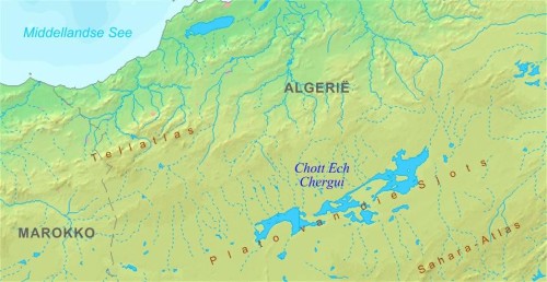
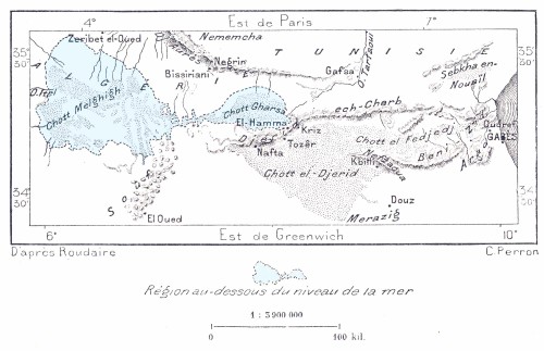
Chotts are dry salt beds that contain varying amounts of water for just part of the year before evaporating away. The resulting salt beds build up over the years and some are vast, suggesting that they were once filled to a much larger extent and could have been year-round features in distant times. And the tantalizing bit? Many of these region lay well below modern sea levels.
Roudaire was not alone in the realization that came next. An Englishman named Donald Mackenzie had studied the El-Djouf plains in what is modern day Mauritania and Mali and come up with a similar, ambitious idea.
The idea was nothing less than a man-made sea in the depths of the Sahara.
Roudaire, Mackenzie and others all had various plans to cut channels from the Mediterranean or even the Atlantic and flood the deep and extensive areas of the Sahara that lay below sea level. Estimate vary widely based on the exact regions and plans, but ranged up to 60,000 sq miles (larger then the US state of Georgia).
In the minds of proponents, the benefits were manifold… from vast trade and transport potential in the northern interior of Africa, to transforming the local environment into a second, lush Mediterranean. Some even claimed it would have such benefits as far away as Europe.
These were not merely flights of fancy either. Major investors and even governments were courted and expressed interest in making these plans a reality
One British magazine, All the Year Round, painted idyllic pictures of trade and tourism, “to carry off the produce of its banks, which will eventually be dotted with groves of date and coconut palms… Hotels, perhaps towns, will spring up on picturesque and eligible sites; luxurious house-boats will float in its most sheltered and shady creeks.”
However, eventually criticism of the feasibility and benefits mounted and over time enthusiasm and support for the various Sahara Sea project faded. From time to time it was resurrected. One U.S. plan, Operation Plowshare, explored “peaceful” application for nuclear explosives, even revisited the Sahara Sea plan. In this scenario, atom bombs would have been used to quickly excavate the necessary channels from the Mediterranean to the chotts of Tunisia.
The Sahara Sea idea was even immortalized in Jules Verne’s 1905 novel, Invasion of the Sea, where European interests study the plan only to ultimately be thwarted/aided by humbling power of nature.
Modern discoveries have even suggested that nature itself had once conspired to create a sea very much like the ones 19th century planners envisioned. “250,000 years ago when the Nile River pushed through a low channel near Wadi Tushka, it flooded the eastern Sahara, creating a lake that at its highest level covered more than 42,000 square miles.” — http://smithsonianscience.org/2010/12/ancient-megalake-discovered-beneath-sahara-desert/