
Savage Gulf Canyon Hike II
 I returned to Atlanta yesterday from Savage Gulf Canyon in Tennessee (having not been eaten by bears). For those not familiar with SGC, it is part of the South Cumberland Recreational Area about 70 miles northwest of Chattanooga, TN. A few years ago, I went on a three day hike and covered a challenging 60-70{a31f233dcfb9a68fbfb0fafc3ce96f3dbf18fa49e3f406b8ddf4c360aa321eb6} of the primary trails. On this trip I wanted to spend two days finishing off the parts of the park that I hadn’t been able to visit on that first trip. I also wanted to take the opportunity to test out my new light/ultralight pack load (details below for the curious and Cyberduck). A brief overview of the hike, followed by photographs from the trip.
I left Atlanta very early Saturday morning and I was a bit surprised how chilly it was. I immediately decided that I’d be taking my micro-fleece jacket with me that I had in the car as an afterthought originally. The traffic on I-75 North out of Atlanta was light until Chattanooga where things slowed a bit until I exited onto US-27/TN-111 and left the city. Nothing but clear sailing after that.
I’ve driven this segment of TN-111 many times in the past when I used to LARP at Fall Creek Falls State park and its a pretty scenic drive. This particular morning very dense fog banks filled every dip and hollow of the terrain. At points it looked like surf pounding on the hillsides and slopes in slow motion. From TN-111, the turn off to Savage Gulf is clearly marked. It’s also at this point that you have your last change at civilization in the form of a Mom & Pop convenience store and gas station. I’ll always remember this particular spot as the place where my former room mate, Chapel of Words, made his first acquaintance with the Tennessee State Patrol in his GMC Typhoon (“Ya’ll mind if we take a look inside your vehicle…”).
Although I’d been to the Savage Falls Ranger Station on the eastern tip of the park before, I still managed to overshoot the entrance on the first pass before realizing it. Once I reached the station I found a park employee on duty, the incredibly friendly Anita, who signed me in, informed me of trail and water conditions, as well as how many people were in my chosen area. I registered an itinerary to the Hobbs Cabin campsite in the back country, got my pass and I was on my way. I had forgotten that this park does not charge for parking or backcountry passes, so I made a mental note to donate the amount most parks charge to the Friends of South Cumberland State Recreational Area, a volunteer organization that works with the park system.
My chosen hike wasn’t particular long by my past standards; approximately 14 miles of winding trails and spurs the first day and around 12 miles on the return trip. It was designed so that I’d get a good mix of terrain (canyon walls, plateau forests, streams and deep forest) as well as covering in the entire northeast trail system of the park.
I hadn’t gone half a mile however I passed a guy out with his dog. Now, I’m of a mixed mind about dogs and hiking. One part of me is well aware of the dangers, impact and responsibilities of taking pets into the backcountry. On the other hand, I acknowledge that its stimulating and bonding for both dogs and owners. However, this guy was “walking” an unleashed pit bull on the day hike loop which is frequented by families and casual hikers. 🙁 Not a hundred yards later I thought I was imagining things when I heard a series of low, plaintive “meows” coming from somewhere. It took me a while to realize that they were coming from above me. It appears that our friend had treed a cat on his outing. It took some coaxing but eventually the cat came down. Turns out, she’s an “unofficial” resident at the ranger station living off the “unofficial” affection and “unofficial” hand out of park employees and hikers. In any case, she was very affectionate and it took me a while to get back underway.
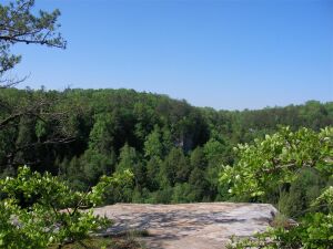
The Savage Day Loop is a pleasant trail that winds through some gentle woodlands and fords a few modest streams. There is even an overnight camping area here for those that don’t like to wander too far from the comforts of cars and coolers. Spring is still getting a grip here and small wildflowers are in their early stages. The firs of the area are all tipped with this years tender, bright green needles. I took the western branch of the loop, which takes you across the Boyd Branch via a narrow suspension bridge. Even a brisk walk sets this bridge bouncing, reminding me of the dire warnings of “resonant frequencies” when columns of soldiers are marching. I’m exaggerating, of course, but the park has posted signs advising no running, no jumping and a limit of two persons at a time. My next treat was a spur off the Savage Day Loop where one can see the churning waters of the Savage Falls from a downstream vantage point. I lingered for a bit before returning to the loop. Next, Rattlesnake Point Overlook is the first of the many, many overlooks visitors taking this route get treated to. Rattlesnake Point is particularly beautiful and bears a dedication plaque to early champions of the park.
At its northern most point, I took my leave of the Savage Day Loop and stepped onto the Northern Rim trail. True to its name, this trail runs along the edge of the northern canyon wall, occasionally, just a few feet from the rim and at other times dipping back into the cool forest. All along its length, short spurs allow hikers to walk out onto overlooks where you can look across the width or down the length of the canyon or just dangle your feet off the edge and enjoy the sunshine and the breeze. Looking down on the treetops from the rim isn’t for everyone, however. Back in 1984, a section of the rim decided it would rather be part of the canyon floor, requiring a re-route of the trail to say the least. You can still see the effects between the aptly named Loose Rock Overlook and the Lick Creek ford.
Just short of the halfway point of the North Rim trail, I detoured onto Mountain Oak trail. Mountain Oak serves as a link between the North Rim trail and the North Plateau trail. Some people use it to form a short loop trail, more challenging than the Savage Day Loop. I chose the Mountain Oak trail so I could form a giant figure eight between between the Savage Day Loop and the Hobbes Cabin camp site.
Mountain Oak cuts sharply away from the canyon rim and the stunted pines and tangled laurels of the windswept rim quickly give way to broadly crowned Oaks as well as towering Shortleaf Pines and Poplars. The best of these can be enjoyed by taking the Big Tree Spur, a loop trail about one-third of the way along the Mountain Oak trail. After this side trip, I returned to Mountain Oak until it dead ended into the Northern Plateau trail.
The Northern Plateau trail is a different world entirely than the canyon eco-system. Parts of it are bone-dry and thin canopy lets delicious sunlight filter through. This is at a cost though. Long sections of this trail have been heavily hit by the Pine Beetle and for stretches you cannot find a single living pine. Those that have not already fallen, are standing dead wood, waiting until the rot weakens them enough for the next wind to topple them too. In the alarmingly large clearings, smaller trees of various species are in a cut throat race to take up the gap in the canopy. Opportunistic blackberry brambles are enjoying their short term dominance, but I think I’m either too early or too late to enjoy their fruits. The air is heavy with chlorophyll and the rich earthy scent of wood compost. Neither of these is unpleasant in themselves, mind you, unless you linger on their ultimate cause… a voracious insect no longer held in check by colder winters of the past.
This segment of the Northern Plateau lacks the dramatic scenery of the rim trails, but the solitude loans itself to getting lost in your thoughts, but the warm patches of sunshine and numerous jumbles of fallen pines are ideal rattlesnake and copperhead terrain (as the park stresses), so anytime I had to leave the trail or cross fallen debris, I made sure to tap out a wide, noisy arc in front of my with my hiking pole. I met one of the serpentine inhabitants of the park on my previous trips and have no doubt he/she has relations in this part of the park as well.
On the topic of the trails here; I’d like to say that even between the ravages of storms and pine beetles, the trails are still very well kept and debris is a fairly uncommon occurrence. Rectangular white blazes appear frequently at idea height. Blue blazes mark spurs and side trails and appear with similar diligence. Even a novice hiker should have no trouble navigating as long as they keep their eyes open and feet steady.
The Northern Plateau eventually makes its way back west, crossing a few old jeep trails and at least two semi-permanent streams of clear water suitable for filtering or other treatment. I took this opportunity to test a new connector that allows me to pump water directly from my water filter into my hydration pack without removing the latter. I have to say, its wonderful not having to unpack or shuffle gear around (and in some cases, not even take your pack off) to refill. I highly recommend the Camelbak Filter Adapter to anyone using a filter and compatible hydration bladder (it can be fitted to many Platypus hydration systems too).
Hobbes Cabin is indeed, a cabin. Its the basic, bare minimum bunk house LARPers may be family with, minus the electricity. A stone fireplace occupies one end and three, two-person bunk beds occupy the other three sides. A good sized porch runs the length of either side, but hikers must supply their own seating arrangements, mattresses and bedding. A couple had arrived there sometime before me, so I chose to take up one of the primitive sites farther away. I was looking for my own privacy as well as wishing to respect theirs. This not a rule, however and the cabin is open to all, until filled.
My site was the farthest back and I took a moment to lay out my gear and inflate my sleeping pad. Propping it up against a log, I put on a cup of coffee and decided to read a bit as sundown and dinner were still a good while off. With a couple chapters finished and twilight approaching, I decided to succumb to ambiance and take advantage of the stone fire ring provided. I gathered a modest supply of tinder and larger deadfall and built the makings of a fire. As soon as the sun went down I lit it. Although the wood was a bit moist, it took and soon I had a tidy fire to keep Sasquatch and insects at bay. 🙂
Dinner consisted of (nearly) instant brown rice, curry, lentils, carrots, diced potatoes and peas. I had packed a large portion but had no trouble finishing it all. After bagging my trash and the rest of my food, I hung my bag in a tree and checked my sleeping arrangements.
As this was an light excursion, I had dispensed with my tent and instead packed a full length bug net and a tarp. I did not need the later as the weather was clear. The temperature dropped to a cozy 50F or so, easily manageable by the light sleeping bag I’d brought (another weight compromise). The bag only had one significant shortcoming. I turn quite a bit in my sleep and the snug, mummy design of this model (Flash Kilo) was a bit restricting. I’ll probably be looking into a roomier replacements even if it means a bit more weight. The bug net was an excellent choice, as a few die hard insects proved undeterred by Deet or smoke. Through the sheer mesh I watched the moon rise and a picked out a few of the more obvious constellations through the tree tops.
I woke slightly at the uncharacteristic hour of 4:30am to discover that one insect had somehow overcome the bug netting. About a two feet above my face on the INSIDE of my netting was the larval form of a cicada. I thought, oh, that’s interesting and went back to sleep. Nonetheless, I kept waking up periodically as the cicada molted into its winged adult form. At one point, I managed to snap a photograph.
I finally awoke in earnest around 7pm, my guest was still completing its transformation while I made coffee and Maple Walnut & Raisin oatmeal. While I exercised the delicate art of drinking from a titanium cup, a large owl hooted his farewells and the songbirds arrived for their shift. Not wishing to play leap frog with other hikers at the camp, decided to break camp early and get on the trail. I removed the still-soft cicada from the bug net and placed it on a nearby log to complete its arduous transformation. Packing up such a light load was a delight and I found myself filtering water down by the spring for the day in no time.
I took the North Rim trail south out of Hobbes Cabin camp and began covering the half of that trail that I’d bypassed the day before. I came to stunning vista after stunning vista taking the opportunity to enjoy and photograph each. The air tasted a bit like rain, but I was confident it would be dry for the hike back. This part of the canyon wall reaches 1800-1900 feet in elevation and if you keep a sharp eye out you will find bits and pieces of coal, from a seam that lays below the surface. This seam and many other layers were laid down during the Permian and Carboniferous periods between 250 and 325 million years ago, when this area was alternatively coast line and shallow seas and expanses of giant fern trees lived and died.
Reaching the Mountain Oak trail again from its north side, I cross over to the Northern Plateau trail and turned south, beginning the final leg of this figure eight. The southern portion of the Northern Plateau is cooler, denser and dark than the northern leg. Several small, seasonal springs can be found along its length, but nothing daunting until you reach a suspension bridge where the trail rejoins the Northern Rim trail. From here, it was a matter of returning to the eastern arm of the Savage Day loop and a few short miles to the ranger station.
I found the station unoccupied, so I relaxed (not realizing check-out was not mandatory). I made small talk with a few passing day hikers and car campers as well as a group of German tourists. The “unofficial” cat decided to take up residence in my lap until I’d given up on the ranger and decided to leave a note. Of course, he showed up then and explained the normal checkout procedure (none, grin). Minutes later I was on the road back to Atlanta with a relaxing and invigorating hike behind me.
The Photographs (labels and details to come later)
The Gear
| Therm-a-Rest Z-Lite, Regular Sleeping Pad | 15 | Includes sack |
| REI Kilo Flash Sleeping Bag | 19 | Goose down goodness |
| Cocoon Ultralight Air-Core Pillow | 3.5 | A rolled up jacket doesn’t cut it for me. |
| Braided Nylon Cord, 50′ | 2.5 | 300lbs tensile strength |
| REI Trekking Pole | 10 | Serves as trap/netting support |
| REI Jet UL Backpack | 22 | 1830cu |
| Compression Sack | 4 | For sleeping bag |
| First Aid Kit | 17.6 | Break down listed separately |
| Hygiene Kit | 5.1 | Break down listed separately |
| Maps | 2 | Two heavy laminated sheets |
| Swiss Army knife | 3 | Simple but effective |
| Outdoor Products Packframe Poncho | 9 | Personal poncho & camping tarp |
| Coghlan Tool | 1 | LED, Compass, Whistle, Mirror, Therm |
| Heatsheets Emergency Bivvy | 3.2 | Emergency warmth, heavy duty groundcloth |
| Water Purification Tablets | 1 | Back up for water filter |
| LED Headlight | 4.4 | Fiat lux! |
| Backup LED | 0.1 | Fiat lux… again |
| Insect repellent | 1.5 | NEVER forget this |
| Sunscreen | 1.5 | Rarely needed in heavy forest |
| Socks | 3 | 1 extra pair |
| Underwear | 3.5 | 1 extra pair |
| Bandanna | .9 | Useful as a hitchhiker’s towel |
| Food, 2 days | 30 | Meals+1, snacks |
| Water, 100oz | 96 | More than I needed between refills |
| Food Bag | 3 | For hanging & storing |
| 110g Fuel Cannister | 4 | Fits inside cookset |
| Primus Micron Stove | 3 | Tiny but powerful, fits inside cookset |
| Snow Peak Mini Solo Cookset | 5.5 | Pot, cup, lid |
| Spork! | 0.6 | Fun to say, fun to use |
| Katadyn | 11 | Heavier, but solid & field serviceable |
| Platypus Big Zip Hydration Bag | 4.5 | 3-liter, 100oz capacity |
| 2 Mini-butane lighters & firestarter | 1.5 | Fire good, hypothermia bad |
| Digital camera & Case | 12.4 | No pictures? Didn’t happen |
| Ipod, case & earbuds | 6.7 | Also good for mini-ebook reader |
| Garmin eTrex GPS Unit | 5.3 | Need to learn better logging techniques |
| Paperback Book | 4.5 | Get your read on. |
Total Weight: 320.8oz
In a peculiar twist of physics, the final weight was slightly less than the weight of the individual items (my postage scale apparently rounds up to the nearest tenth of an ounce). The lean pack weight was originally 18lbs, but I decided to treat myself to some luxuries (gadgets, book, etc) as a reward bringing the new total to 20lbs. In retrospect, I would replace my sleeping bag with a slightly wider model to accommodate my sleep style. I would probably ditch the GPS unless I was spending more time in open ground (lost satellite fix frequently in heavier forest) and add my mini-tripod (4.9oz). Finally, I would add a small notepad & pen or voice recorder to better document my thoughts.
If I added my lightest tent (one-person + gear) this would add 30oz. My two-person + gear tent, would add 48oz. My winter sleep system would add a net 35oz, but I can probably find a lighter bag if I’m willing to pay the expense of down or down-hybrid.


Hey Geoffrey, I love your pictures and the article was well well written. Nice trip!
Sounds fun. I love owls. Hoot, hoot.
Thanks, guy, I really appreciate the comments. Let me know how your upcoming hikes go too, Jenni.